Views obtained using Google Earth
Close-ups
September 3, 2005
1 - My house in Pertuis:
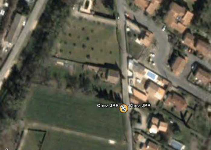
The Villa Jean-Christophe
2 - Area 51
First, a general view. It is crossed by the world's longest runway.
Area 51. General view. Clearly labeled "Groom Lake": a dried-up lake.
Have you ever seen a runway ending straight into a hill? Neither have I (question mark). Zoom in on this corner.
The northern end of the runway, over 8 kilometers long
Let's take a closer look.
The northern end of the runway
Along this endless, 30-meter-wide runway, the white centerline marking is clearly visible. We know that all secret tests ("Black Bird" SR-71, F-117A "Nighthawk") were carried out at night by those who called themselves the "Road Runners"—a name also given to a desert bird that runs very fast across the ground. It was logical to have a continuous centerline marking along the entire runway so pilots could orient themselves while taxiing. But why does this marking go "straight into the wall," when there are parking spaces on the right? I'd wager this line indicates the entrance to hangars carved beneath the hill. The image likely corresponds to a photo taken from an altitude of one thousand meters. I amused myself by trying to reconstruct an oblique view of the site (which major powers have had for a long time. Let's recall that today, under clear skies, one can recognize a person's features from space).
Readers have asked me why it seems so easy to access images of this legendary Area 51. Indeed, its size appears relatively modest, aside from the runway's length—over 8 kilometers—hardly concealable. But what we see is only the tip of the iceberg. The rest lies deep underground. There are several reasons for this. Of course, discretion is one. But very quickly, Americans wanted to protect their sensitive installations from nuclear attacks. Hence, installations were built at depths... impossible to estimate. It's uncertain, aside from the extraordinary 30-meter-diameter runway, that sensitive underground U.S. facilities remain concentrated in such "highlighted" locations. This is precisely what is hinted at in Spielberg's TV series "Taken" (abductions), when one official says, "We're moving elsewhere, while the gullible will keep trying to uncover the secrets of this Area 51 with their binoculars."
September 8, 2005: Philippe Meobel suggests that the "tarmac" at the end of the runway (which allows aircraft to turn around for takeoff in a better direction relative to the wind) might actually be... an elevator exit.
September 6, 2005: Google Earth: Fake "3D"
When using Google Earth, you have controls at the bottom right that allow you to tilt the image and thus obtain a perspective view. You've probably wandered through rugged terrain this way, like in a ravine or between mountains. You may have noticed that the software, in addition to reloading views at different resolutions, gradually adjusts the elevation of the terrain. This can create the illusion that the massive Google Earth file contains actual 3D data.
It's true that such data can exist, since modern satellites no longer take only vertical images. By approaching their target obliquely, they can capture 3D views by adjusting the sequence of images. Paraphrasing Brassens, one might say that today satellites cast "oblique glances" upon passersby. This has produced stunning images of Mars, for example. The same applies to Earth. This 3D capture of terrain is essential for planning trajectories... of cruise missiles, which often follow deep valleys to evade enemy radar.
Google Earth is fake 3D. Real 3D data has such obvious strategic value that it would never be freely distributed to the public. Therefore, Google employees took a 2D dataset and "bumped up" the terrain with varying degrees of success. I know exactly how this is done, having created a similar tool 30 years ago in my CAD software Screen, which featured an "intelligent" modeler running at 2 megahertz on a 64 K Apple II, later upgraded to 4 MHz on a 128 K (software Pangraphe, then Amstrad: Superpangraphe and Screen). I even appeared on TF1 demonstrating a film shot on an Apple, showing a village with hidden parts removed. We circled the object in a bird's-eye view, displaying monochrome images on a 190 by 300 pixel screen. This was at the very beginning of microcomputing. Back then, such "achievements" were reserved for "mainframes." I should add that at the time, a single moderately sophisticated color image—showing an object behind glass with a few reflections—required 10 hours of computation on a mainframe and cost 30,000 euros.
People asked me, "How could you get an Apple running at 2 MHz to calculate so fast?" In fact, the images (each weighing 8 KB!) were pre-computed and stored in "virtual memory" (256 KB—a first achieved by Apple). CDs didn't exist yet, and thus I was presenting a prototype of future digital imaging. I sold around 1,200 copies of Superpangraphe and Screen by mail in the early 1980s. The source code listing was thirty meters long. So I'm not entirely ignorant in this field, even if I've fallen behind modern programming tools.
Google Earth is a large file containing 2D data. The team at Google improved the mess by applying "a few hammer blows" to certain more pronounced elevations. Let's say that starting from a base where z = 0, the operation assigned elevations to points, with each hammer blow corresponding to a "bell curve" (maximum value, plus standard deviation). If needed, multiple hammer blows are applied in the same area. This is for hills. For certain objects, they apply scaling (homothety). But sometimes, the person handling the data had only a very vague idea of what they were working on. Take a look at the pyramids of Giza and view them from near ground level. You'll get this:
You have latitude and longitude to locate the spot. Isn't that angle slightly off? Here, the Google team was a bit too hasty.
Southwest of Marseille lies a chain of islands, one of which is splendid: Riou, rising over 100 meters in height. I made my first climbs there in 1959 with Jean Lecomte. He was on this "deserted island" with his wife Lulu, climbing and... well.
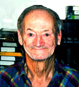
Jean Lecomte
Jean-Claude and I, both twenty years old, had come to survey a site of amphorae near the Imépériaux reef. We hit it off. Jean took us to climb a route facing the sea. We had no shoes, but our feet were so tough from years of climbing that it worked perfectly.
Let's go to Google Earth and search for the island of Riou (which, in Phocaean times, served as a lighthouse for the ancient port. The carved post still stands in h...