Tsunami in Indonesia
Tsunami
January 6, 2005 - **
Updated January 21, 2005 **
Updated January 26, 2005
Condoleezza Rice before the U.S. Senate on January 18, 2005 (quoted by the newspaper "Le Monde"):
"This tsunami is a blessing in disguise, as it allows us to establish ourselves in vulnerable countries to restore democracy and freedom."
Thousands of kilometers of coastline were devastated on December 26, 2004, by a massive wave. The media has already extensively reported on the human and material damage, so further elaboration is unnecessary. Yesterday, the death toll was reported to exceed 150,000. First, here is a simulation of the phenomenon, presented as an animation:
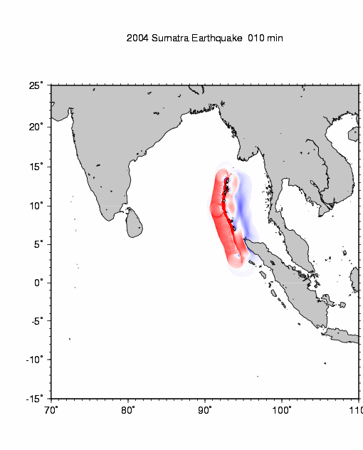
Simulation of the tsunami that struck Southeast Asia on December 26, 2004
Here is a second animation (please be patient: it is 5.8 MB, but well worth it)
You can view it using QuickTime. What is particularly interesting is that you can manually control the animation using the slider and observe, for example, how waves diffract south of Sri Lanka (Ceylon) and how the wave travels back up through the strait separating the island from India. Another observation: the way the wave reflects off the northern coast of Sri Lanka and thus reaches the far northern part of the Bay of Bengal. You will also notice the surprisingly strong impact of the wave when it hits the Somali coast, six thousand kilometers from the epicenter. The various chains of islands encountered, combined with underwater topography not visible in this animation, also create a dissipative effect, weakening the tsunami. As a result, certain coastal areas were relatively spared, located "in the shadow of islands lying in the tsunami's path."
Addition dated January 12, 2005:
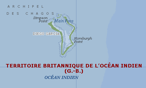
Carefully watch this animation. If you've already seen it, watch it again. You will notice that when the tsunami passes southwest of Sri Lanka, its power remains considerable. The proof: massive destruction and a high number of casualties on the island. Now, what does this tsunami encounter along its path in this region, located south of the Maldives? Examine the maps further down the page. You will find the Chagos Islands, British possessions, which host the famous U.S. military base at Diego Garcia, supposedly the refueling point for B2 bombers during their raid on Kabul (?...). This is a simple atoll, flat, lacking elevation, and offering no protection against a tsunami. Strategic bombers, regardless of type, require runways of maximum length—several kilometers. It is highly unlikely that a runway would be built on such a low-lying atoll, even if it were just ten, twenty, or thirty meters above sea level. It must therefore be located in the lower areas. In any case, at this point on Earth, the tsunami would have had enough force to climb even a gentle slope devoid of any elevation. Each B2 costs two billion dollars. The Americans claim they built hangars at Diego Garcia capable of housing these aircraft. Has anyone obtained information about the tsunami's destruction at this atoll? From what I've seen, there is total radio silence regarding this location. Were the aircraft, so valuable, in flight during the tsunami's passage, or simply... on mission? But who can provide information about this obscure chapter of history?
January 13, 2005: When God is on the side of the Americans.
The readers' responses to my earlier question about the Diego Garcia base, where U.S. B2 bombers are reportedly stationed, have been numerous and their investigations quite thorough. According to satellite photos, the Chagos Islands and the Diego Garcia base, located 3,200 km west of the epicenter and with an elevation not exceeding eight meters, appear to have suffered no damage whatsoever from the tsunami.
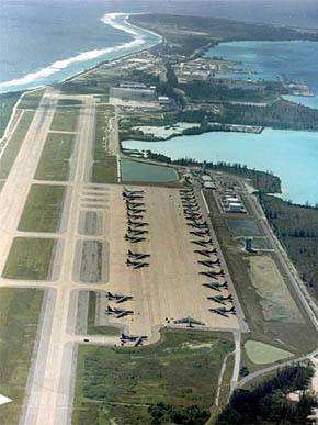
These images of the Diego Garcia base were sent by Eric Munier:
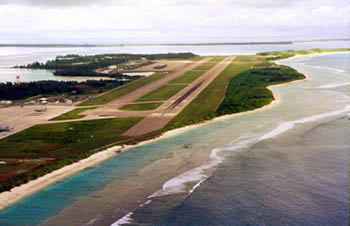
The air base at Diego Garcia, leased by the Americans from the British in the Chagos Islands, located southwest of Ceylon and south of the Maldives. It is hard to imagine a flatter terrain.
U.S. base at Diego Garcia
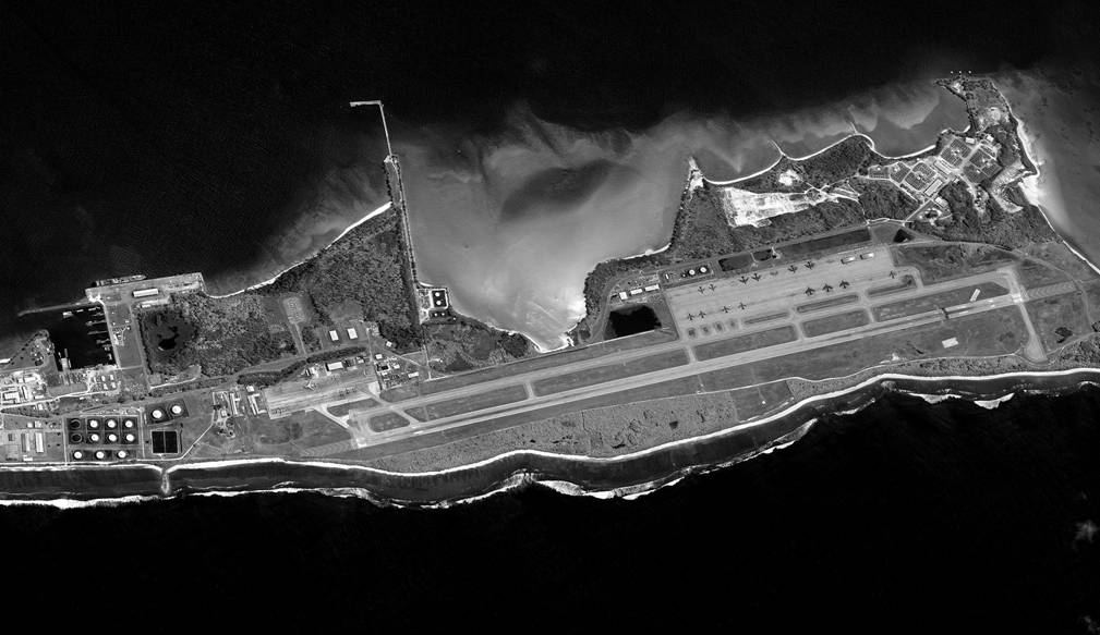
U.S. base at Diego Garcia. Satellite view.
I don't know when these photos were taken. In the satellite view, two lightweight hangars are visible to the right of the tarmac, supposedly designed to shelter the B2s from "the rigors of weather." Their radar-absorbing coating is reportedly "quite fragile." Odd for aircraft that fly at high altitude and are constantly exposed to UV radiation. It's hard to imagine strategic bombers, capable of operating at any moment, being concerned about... weather. These hangars are not visible in the other photos. Perhaps they are used to conceal the B2s from view. But why hide them if these aircraft have been photographed countless times from every angle? Unless the "real B2s" differ somewhat from those displayed? Final hypothesis: these hangars have never housed strategic bombers, which do not need to refuel at Diego Garcia to conduct circumglobal missions at hypersonic speed, launching directly from the United States. See my dossier on the mysteries of the B2.
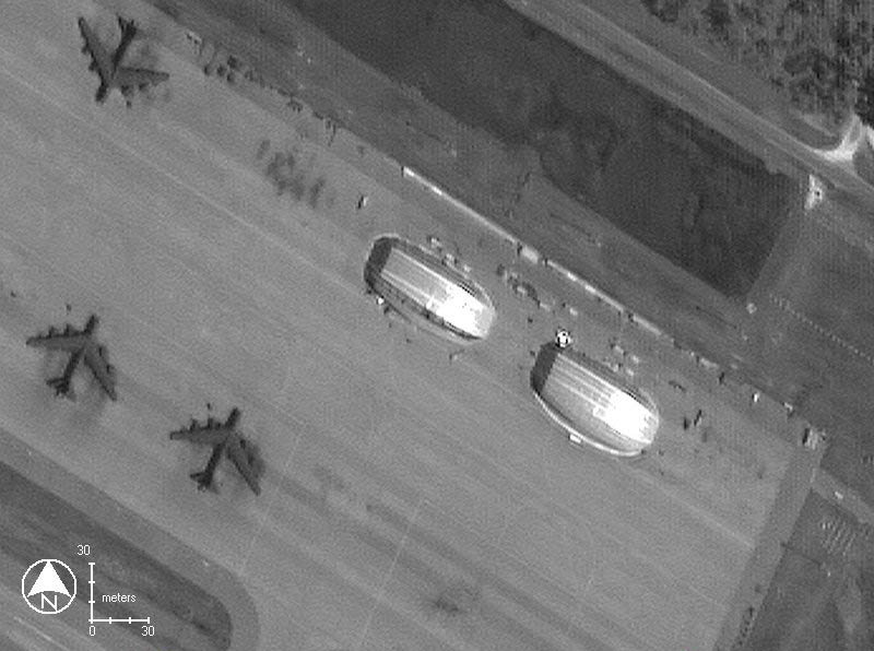
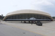
B2 hangars. Next to them, B-52s
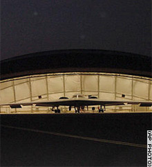
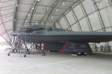
A B2 inside its lightweight hangar
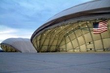
Additional views of these lightweight hangars
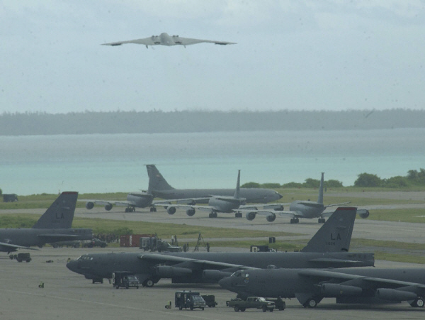
B2 bomber taking off from Diego Garcia (in principle...). In the foreground, B-52s, and behind them, KC-135 aerial refueling aircraft.
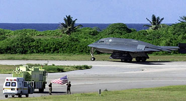
A B2 on the runway at Diego Garcia (in principle...)
That these islands, with an elevation not exceeding eight meters above sea level, might seem paradoxical. But as stated on an official website:
http://www.dg.navy.mil/2005/html/news_flash.htm
the islands appear to lie west of a very pronounced oceanic trench, 600 kilometers long and oriented north-south, with depths reaching 5,000 meters. This is one of the deepest points in the Indian Ocean. Here is what I could find regarding the seabed map of the region.
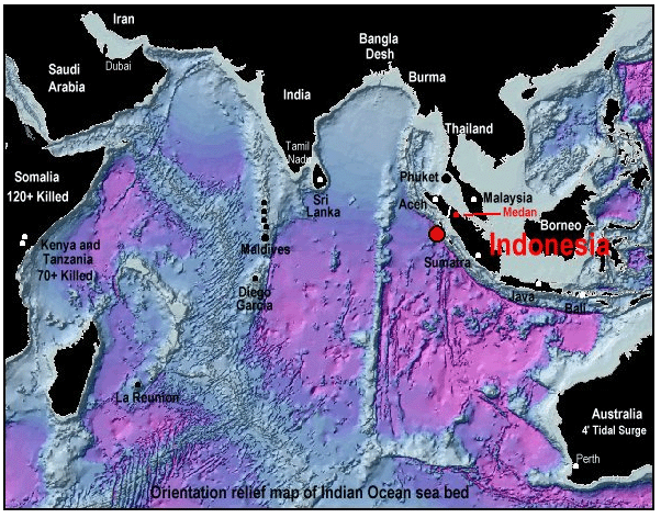
Indian Ocean. Seabed map. Red dot: measured epicenter
Only a more precise seabed map of the Diego Garcia area would allow a clearer understanding. Indeed, if a seabed rise amplifies a tsunami's destructive power, an increase in depth reduces wave height! The Chagos Islands are very low-lying. However, according to official statements, the presence of the oceanic trench acting as a "barrier" limited the wave's rise to just a few meters. Let us clarify: a tsunami is not accompanied by any air movement or wind.
Let us be precise. A tsunami carries a certain amount of...