Tsunami subduction earthquake
Tsunami File
Information collected after January 15, 2005
Previously
before January 15, 2005
On December 26, 2004 at 0h58 (Universal Time), that is 1h58 in Paris and 7h58 in Sumatra, one of the largest earthquakes ever recorded occurred, with a magnitude currently estimated at Mw=9.0. Figure 1 shows the vertical ground displacement during the passage, in Europe, of the seismic waves associated with the earthquake of 26/12/2004. The vertical ground displacement reached an amplitude of 2 cm. Such a displacement, although exceptional, is not perceptible to humans, because the wavelength of the phenomenon is on the order of hundreds of kilometers. A quick note: the daily passage of the Moon causes a "terrestrial tide" of about 50 cm, if my memory serves me right, and we do not feel it.
Below is the recording of the Indonesian earthquake made in Europe:
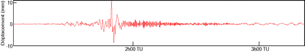
**Signal recorded by the seismograph in Europe. Maximum vertical displacement: 2 cm. **
Below is the location of the earthquakes, the main earthquake and its "aftershocks".
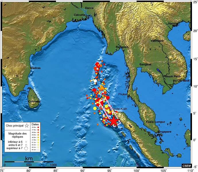
Map of the seismic event of December 26, 2004 (main earthquake plus aftershocks)
Seismic-tectonic context
The region of the island of Sumatra is a boundary zone between two tectonic plates. The Indo-Australian plate is subducting under the island of Sumatra at a speed of about 5 cm/year (subduction zone). The deformation of the coastal region of the island, caused by this rapid convergence, is accompanied by the occurrence of very strong earthquakes. The events of 1833 (Magnitude ~9) and 1861 (Magnitude ~8.5) thus ruptured the subduction interface over nearly 500 and 250 km in the center of the island, releasing several decades of stress during seismic slips of several meters in amplitude.
More recently, the strong earthquakes of 1935 and 1984, more moderate, ruptured small areas adjacent to these major ruptures. However, no major seismic event was known in the area adjacent to the north, and this until the Nicobar and Andaman islands, where the ruptures of 1881 and 1941 (M ~8) generated tsunamis.
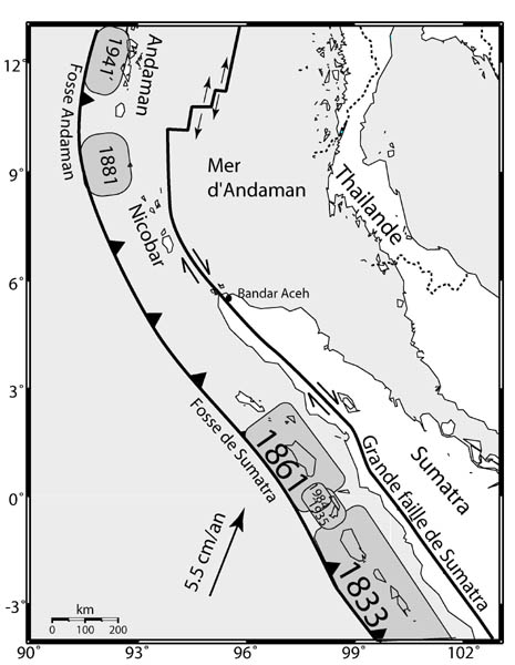
**Regional plate tectonics. **
It seems that the tectonic phenomenon began at a point located northwest of Sumatra, then quickly spread over a slip line extending over 600 to 1200 km (this length corresponds to the evaluations provided by the different specialized laboratories). Whatever the value retained, this explains the exceptional destructive power of the tsunami. Usually, the water level variation is near an epicenter. The wave, or train of waves, then propagates in concentric circles. The energy carried, in joules per meter, on the perimeter, decreases inversely with the distance. But here we were not dealing with a point or quasi-point source, but with a phenomenon representing a slip over an entire line. As can be seen very clearly in the simulations, it is a wave that propagated almost linearly, in an east-west direction. Thus, its energy was roughly conserved. This explains the residual power of the phenomenon in Sri Lanka and, much further west, towards Somalia.
It is the amount of solid material involved in the plate slip phenomenon that caused a slight but lasting tilt of the Earth's rotation axis. The amplitude of the slip depends on the evaluations. It ranges from 16 to 35 meters.
This axis is not fixed. According to Souriau, seasonal meteorological phenomena would cause movements of fluid masses on the surface of the Earth, liquid (oceans) or gaseous (air and water vapor contained in this air). These movements would have an impact on the position of the Earth's rotation axis, which would then oscillate around an equilibrium position according to a sub-metric, small, but measurable movement.
The Sumatra earthquake was accompanied by an irreversible displacement of solid masses. Therefore, it resulted in a lasting alteration of the position of the Earth's rotation axis. By how much? Let the geophysicists answer us. Given that the Earth's radius is 6400 km, a displacement of one meter corresponds to a tenth of a microradian. Therefore, let amateur astronomers rest assured. The North is still indicated by the North Star.
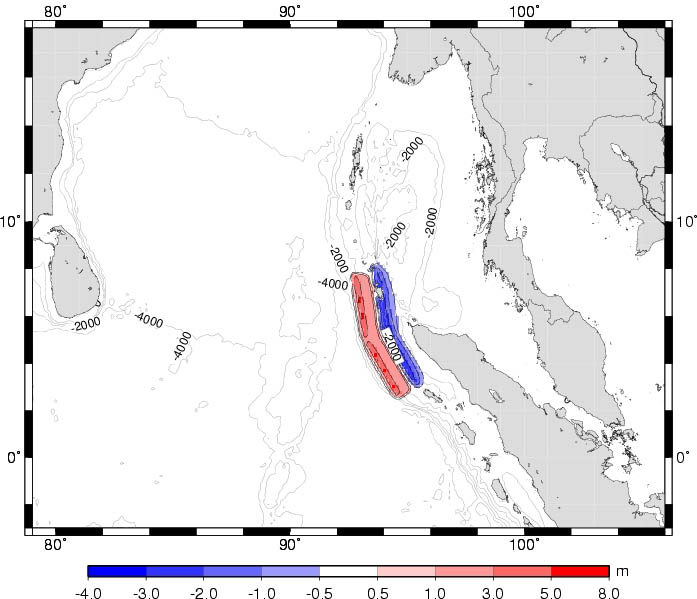
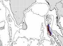
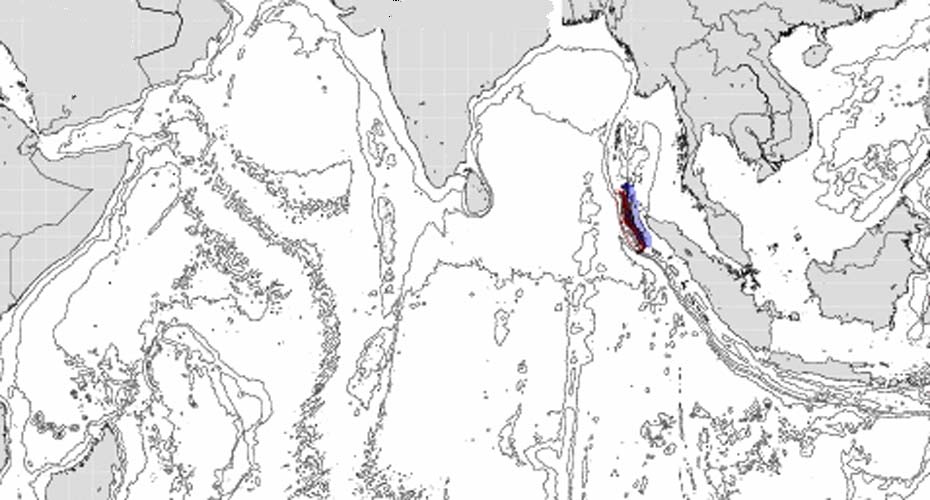
**Initial conditions considered for the simulation of the phenomenon. Note the depths of the trenches and the water heights, in meters. **
According to the data provided ( http://www-dase.cea.fr/actu/dossiers_scientifiques/2004-12-26/index.html ), the moment would be 3.7 10 22 newton meters. Apart from these data, a numerical simulation is performed which gives the main features of the phenomenon. The reader can watch it at the address indicated above. It does not differ from that given in the previous page.
On this map, some contour lines indicating the depths are shown. I have extracted what could be located to the east of Diego Garcia, the famous trench that would have protected the American air base. Perhaps someone could provide us with more precision on the depths at this point of the globe.
The following image (source CEA) shows the maximum wave amplitude in the different regions affected.
-
Dark brown: 3 meters: on the islands located near the tsunami's starting line (Andaman Sea, area located north of Sumatra).
-
Terra cotta: between 1 and 3 meters. In the Bay of Bengal: between 10 and 50 cm.
-
Near the Maldives and the Chagos Islands (Diego Garcia), light green: 60-70 cm.
-
Somalia: dark blue, thirty centimeters.

This map only indicates the anisotropy of the phenomenon: its propagation in an east-west direction. After that, on one side, it depends on how the seabed rises. If the rise is abrupt, the coast is protected. If it is gradual: maximum damage. This brings us back to the seabed map.
Seabed map
For example, it seems that the Phuket region was particularly poorly situated in this regard, with a very gentle seabed rise over a large continental shelf dotted with islands.
We know that tides have very variable amplitudes depending on the regions of the world. Yet the Moon acts in the same way at all points of the globe. The shape of the seabed, near the coasts, then plays a role. The Mediterranean "breathes" at the rhythm of the tides. But the effect is little noticeable on the coasts, especially because they are "relatively flat", and the seabed drops off quite quickly. The shape of the coast is thus not conducive to the amplification of the "tidal wave".
Opposite situation in the English Channel and especially in the Mont Saint Michel bay, where one can observe differences in water levels of six meters, simply because in this area the seabed rises very slowly and this ultra-soft slope is conducive to the phenomenon of "tidal wave" amplification.
January 15, 2005: Simple remark. The CNES has a DEMETER project to study the potential im...